Partial diversion of
the Rivière Rupert
A green kilowatt: a very profitable drop of water
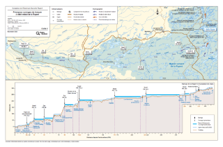
The same water is used to generate electricity four times
Since being commissioned on November 7, 2009, the Rupert diversion has channeled part of the river’s flow to Eastmain‑1 generating station and the two new generating stations (Eastmain‑1‑A and Sarcelle), then on to Robert‑Bourassa, La Grande‑2‑A and La Grande‑1 generating stations. The mean annual diverted flow is 452 m3/s or 52% (average) of the inflows from the Rupert watershed. The diversion required the construction of four dams, including Rupert dam at KP 314 of the river, and 74 dikes. The retaining structures created two diversion bays (Rupert forebay and Rupert tailbay), which cover a total area of approximately 346 km2 when at their maximum level.
The power of a river
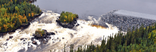
Construction of the Rupert spillway
More than half of the Rupert’s water is diverted to the generating station
The Rupert stretches some 560 km from Lac Mistassini to Baie de Rupert. A dam was built 314 km from its mouth. Here, 71% of the Rupert’s water is diverted north and 29% continues along its previous course. Between the dam and the mouth, the tributaries continue to feed the river. Thus, the flow at the mouth of the Rupert, near Waskaganish, is equivalent to 48% of the river’s mean annual flow. About 52% of the water in the Rupert watershed was diverted to Eastmain‑1 and Bernard‑Landry generating stations.
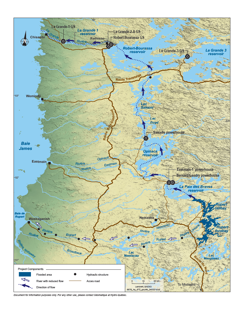
Creation of two diversion bays
Diverting the flow required the creation of two diversion bays, the Rupert forebay and tailbay. Dams, canals and dikes were built to contain the diverted waters in the diversion bays and channel the flow northward. A 2.9‑km‑long tunnel transfers the water from forebay to tailbay. These structures were designed to minimize the land areas flooded.
Instream flows
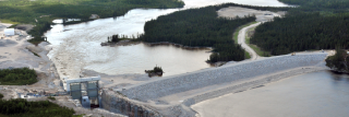
Aerial view of the Rupert at the weir at KP 110.3
A flow adapted to fish life cycle
In order to protect fish habitats and preserve navigation, hunting and fishing, an ecological instream flow regime was implemented downstream of Rupert dam. A spillway that acts as a control structure allows the flow to be modulated according to the four major stages of the fish life cycle: spring spawning, summer feeding, fall spawning and winter incubation.
In Lemare and Nemiscau rivers, two tributaries of the Rupert, release structures are used to maintain flows equivalent to naturally occurring flows.
Instream flows in the Rupert at the diversion point
| Spring flow | Summer flow | Fall flow | Winter flow | Mean annual flow |
|---|---|---|---|---|
| 416 m3/s | 127 m3/s | 267 m3/s | 127 m3/s | 181 m3/s |
| Spring flow | 416 m3/s |
|---|---|
| Summer flow | 127 m3/s |
| Fall flow | 267 m3/s |
| Winter flow | 127 m3/s |
| Mean annual flow | 181 m3/s |
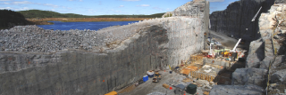
Hydraulic structures downstream of the dam
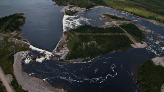
Rupert dam and spillway
What is a diversion bay?
The partial diversion of the Rupert required the construction of a series of hydraulic and retaining structures, including a rockfill dam on the Rupert and three sand and gravel dams, one on Rivière Lemare and two on the Nemiscau. A 2.9‑km‑long tunnel was built between the Lemare and Nemiscau watersheds, as well as 9 canals and 74 dikes.
These structures created two diversion bays connected by the tunnel, through which water is channelled into Paix‑des‑Braves reservoir. The net mean annual diverted flow is estimated to be 452.6 m3/s. Unlike reservoirs, diversion bays are not used to store water.
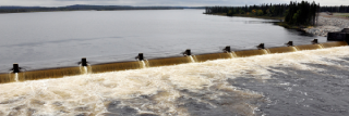
Aerial view of a weir at KP 170 of the Rivière Rupert
Forebay
The forebay is located upstream of the transfer tunnel. It is 50 km long and covers an area of 228.7 km2. The Rupert dam and spillway, as well as Lemare dam and the instream flow release structure are located in the forebay.
- A system of 33 dikes was built to close off the west and north sides of Rupert forebay
- Four canals take the diverted waters of the Rupert across the drainage divide into the Rivière Lemare watershed, while limiting the maximum level of water bodies and flooded areas
Tailbay
The tailbay is located downstream of the transfer tunnel. It is 44 km long and covers an area of 117.5 km2. Nemiscau‑1 dam , Nemiscau‑2 dam and Ruisseau‑Arques dike, as well as their instream flow release structures, are located in the tailbay.
- A system of 41 dikes was built to close off the tailbay
- Five canals were built to ensure a good flow of water
- These works involved the partial relocation of three existing transmission lines
Hydraulic structures built on the Rupert to maintain water levels and ecological functions